What is the Equal Earth map and why UN voted?
TL;DR
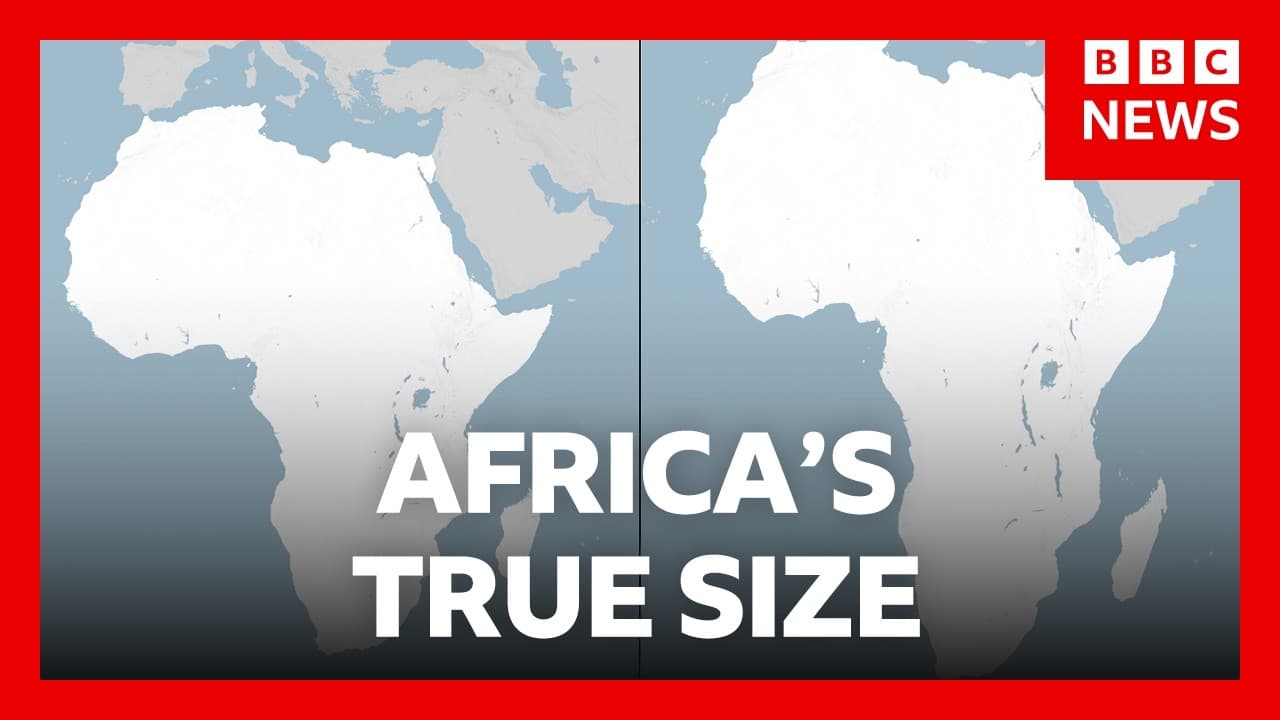
The UN General Assembly backed a non binding move to phase out the traditional map in favor of an equal area projection that reflects Africa’s size more accurately. The decision received broad support, with the United States the sole dissenting vote and several nations abstaining. The change could influence maps in education and government, though it is not mandatory.
Transcript
So, let's get a little bit more on that UN General Assembly vote in support of phasing out the traditional world map with one that more accurately reflects the size of Africa. The non-binding UN resolution proposed by Togo was backed by almost all member states. Only the United States voted against it. Critics point out that the traditional Merka m... Read More
Key Insights
- The UN General Assembly voted in support of phasing out the traditional world map in favor of a more accurate representation of Africa’s size.
- The Equal Earth projection is an equal area map that maintains continent sizes while distorting shapes differently than traditional maps.
- The decision is non binding, so adoption depends on institutions and governments choosing to use the new projection.
- The United States voted against the resolution, highlighting a perceived ideological dimension to map projections.
- Most other member states supported the change, indicating broad international interest in more accurate geographic sizing.
- Experts note that different projections serve different purposes, such as navigation or accurate area representation.
- Countries near the equator appear larger or smaller depending on the projection, influencing perceived political and geographic importance.
- The discussion includes considerations of how maps affect education, public health, and international aid planning.
Install to Summarize YouTube Videos and Get Transcripts
Explore YouTube Video Summarizer or Get YouTube Transcript Extractor
Questions & Answers
Q: What is the Equal Earth map and how does it differ from traditional maps?
The Equal Earth map is described as an equal area projection that aims to maintain the true size of continents on a flat map, unlike traditional maps which may distort size. This projection addresses how Greenland and other regions can appear disproportionately large or small, affecting perceived geographic significance.
Q: Why did the UN General Assembly vote to support a new world map?
The vote supported a non binding measure to phase out the traditional map in favor of one that more accurately reflects Africa’s size. Support came from many member states and the resolution is intended to influence educational and governmental map choices, even though it is not enforceable.
Q: Which country voted against the resolution and why is that notable?
The United States was the only country to vote against the resolution. This stands out because most countries supported the change, highlighting a potential ideological dimension to map projections and a preference for using maps that center or favor different geographic representations.
Q: What is meant by a non binding UN resolution in this context?
A non binding resolution means the UN cannot compel member states to change their maps. It serves as a recommendation or guidance that could encourage adoption by schools, agencies, and governments, influencing future choices without creating legal obligations.
Q: How might this map change affect education and government?
If adopted, education materials and government maps could increasingly use the Equal Earth projection to present continents with more accurate relative sizes, potentially altering how students and policymakers perceive geographic relationships, resource distribution, and regional importance.
Q: Are there trade offs when choosing different map projections?
Yes, different projections emphasize different aspects; navigation often prioritizes shape and angles, while equal area projections prioritize size accuracy. Choosing a projection involves balancing distortions in shape versus size, which can influence how continents and countries are perceived.
Q: What does the transcript say about countries near the poles versus near the equator?
The transcript notes that projections behave differently for regions near the poles and the equator, with polar regions often becoming distorted in some projections and equatorial regions appearing differently sized. The Equal Earth projection seeks to address size distortions for better overall accuracy.
Q: What role do experts say projections play beyond simple geography?
Experts suggest that map projections influence public understanding, policy discussions, and decision making in areas such as public health and international aid. By presenting sizes more accurately, maps can change perceptions about which areas may require more attention or resources.
Summary & Key Takeaways
-
The UN General Assembly supported a non binding resolution to encourage a map that reflects Africa’s size more accurately, moving away from traditional projections.
-
The Equal Earth projection is described as an equal area map designed to preserve size over shape, affecting how continents appear on flat maps.
-
The impact of the vote depends on adoption by institutions, education and government, despite the non enforceable nature of the resolution.
Read in Other Languages (beta)
Share This Summary 📚
Summarize YouTube Videos and Get Video Transcripts with 1-Click
Try YouTube Summary with ChatGPT & Claude or YouTube Transcript Generator
Explore More Summaries from BBC News 📚


Summarize YouTube Videos and Get Video Transcripts with 1-Click
Try YouTube Summary with ChatGPT & Claude or YouTube Transcript Generator