What Did Edinburgh Look Like in the 1700s?
TL;DR
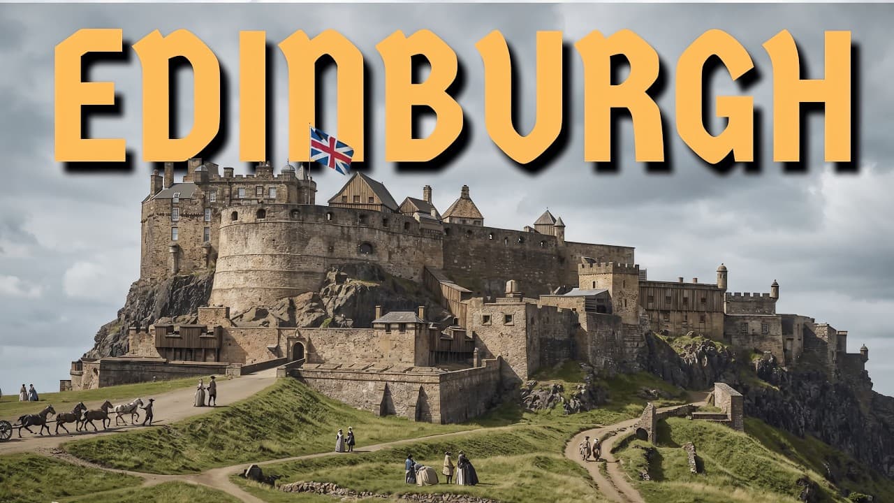
Edinburgh before the New Town was a dense, vertical city confined to a narrow ridge between steep slopes, with the castle and Holyrood Palace anchoring opposite ends. Defensive features such as the Nor Loch eventually became obstacles to growth, so the city drained and reclaimed land, built North Bridge, and began expanding beyond the crowded Old Town.
Transcript
What did Edinburgh really look like before the new town? Before wide streets, open spaces, and planned expansion? And what did it feel like to live in a city shaped by defense, crowding, and centuries of pressure? In this video, I use modern AI tools to bring historic paintings, maps, and engravings to life. The goal isn't just to look at the past,... Read More
Key Insights
- Edinburgh’s Old Town was confined to a narrow ridge, with steep ground on both sides preventing easy outward expansion. This geographic restriction compressed buildings and residents into a narrow strip, encouraging the city to grow upward and producing the density that defined daily life by the 1700s.
- Edinburgh Castle was both a defensive stronghold and a constant presence in ordinary urban life. Built directly into the elevated rock, it dominated the settlement below, while its enclosed spaces supported residence, work, guard duty, maintenance, political authority, and long periods of routine waiting.
- Control of Edinburgh Castle meant control of the city beneath it. The fortress took shape as a royal stronghold in the 11th century, likely under Malcolm III, and subsequently endured repeated sieges, damage, rebuilding, and changes of control during Scotland’s political and military struggles.
- Holyrood Palace was designed for residence, ceremony, and government rather than serving as a final defensive barrier. Located where the city met the countryside, it housed visiting monarchs, councils, negotiations, and royal routines, although its use declined after political power shifted toward London.
- Holyrood Abbey was an Augustinian monastery closely connected to the royal court. It supported worship, burial, and ceremony for centuries, but fell into disuse after the Reformation and stood open to the sky, gradually deteriorating beside the palace by the late 1700s.
- The Nor Loch was an artificial defensive barrier created in the 15th century by damming the valley north of Edinburgh. It later became a dumping place for sewage and waste, as well as an occasional setting for executions and public displays visible from the city above.
- North Bridge marked Edinburgh’s transition from defensive confinement to outward expansion. Beginning in the 1760s, the city gradually drained and filled the Nor Loch, reclaimed the valley, and constructed a connection between the crowded Old Town and undeveloped ground beyond it.
- The High Street connected Edinburgh Castle with Holyrood Palace and functioned as the Old Town’s main artery. Landmarks such as St. Giles’ Cathedral and the Tron Kirk stood amid homes, shops, traders, carts, markets, courts, churches, political arguments, religious activity, and dense pedestrian movement.
Install to Summarize YouTube Videos and Get Transcripts
Explore YouTube Video Summarizer or Get YouTube Transcript Extractor
Questions & Answers
Q: How did Edinburgh’s geography shape the Old Town?
Edinburgh’s Old Town developed along a narrow ridge extending downhill from the castle. Steep ground on both sides left little room for the settlement to spread outward, so buildings and residents became compressed into a dense strip and the city increasingly grew upward. This physical confinement influenced Edinburgh’s defensive form, crowded living conditions, movement patterns, and skyline for centuries.
Q: What was Edinburgh Castle like during the 1700s?
Edinburgh Castle was already hundreds of years old by the 1700s, having been repeatedly besieged, damaged, rebuilt, and contested. Its elevated position made it a powerful military and political symbol that dominated the city below. Inside, however, daily experience was often more routine, consisting of guard duty, maintenance, work, residence, and long periods of waiting.
Q: Why was Holyrood Palace important to Edinburgh?
Holyrood Palace became Scotland’s principal royal residence in Edinburgh after developing beside a 12th-century royal abbey. By the 1500s, kings and queens stayed there while visiting the city. It remained the official royal residence in Scotland during the 1700s, although it was used less after the Union of the Crowns and Parliament in 1707 shifted real power south to London.
Q: How were Edinburgh Castle and Holyrood Palace different?
Edinburgh Castle occupied a high, difficult-to-approach rock and expressed defense, military strength, and control over the settlement below. Holyrood Palace stood at the lower end of the city’s spine in a flatter, more open setting beside the countryside. It was associated with court life, ceremony, councils, negotiations, governing, and royal residence rather than functioning as a final defensive position.
Q: What happened to Holyrood Abbey by the late 1700s?
Holyrood Abbey began as an Augustinian monastery and religious center connected closely to the royal court. It served for centuries as a setting for worship, burial, and ceremony beside the developing palace. After the Reformation, the abbey fell into disuse. By the late 1700s, it no longer functioned as a church and stood open to the sky, slowly breaking apart.
Q: What was the Nor Loch and why was it created?
The Nor Loch was an artificial body of water beneath Edinburgh Castle, created in the 15th century by damming the valley on the city’s northern side. It initially acted as a defensive barrier, but its purpose changed over time. The loch became a dumping ground for sewage and waste and occasionally served as a public setting for executions and grim displays.
Q: Why was the Nor Loch drained during the 1700s?
By the 1700s, the Nor Loch had become less useful as a defensive body of water and more of a problem for Edinburgh. Beginning in the 1760s, it was gradually drained and filled to reclaim the valley. This work created room for North Bridge, which connected the Old Town with new ground and supported the city’s shift from inward defense toward outward growth.
Q: What was daily life like on Edinburgh’s High Street?
The High Street, now identified with the Royal Mile, was the Old Town’s main artery between Edinburgh Castle and Holyrood Palace. It was crowded with traders, carts, residents, worshippers, and people traveling among markets, courts, shops, homes, and churches. St. Giles’ Cathedral and the Tron Kirk stood within this activity, making religion and civic life part of the street’s noise and movement.
Summary & Key Takeaways
-
Edinburgh developed along a narrow ridge, with its castle commanding the rock at the highest point and the settlement extending downhill. Steep ground restricted outward growth, causing buildings and daily life to become densely compressed. This geography shaped the city’s defensive character, crowded streets, vertical development, and recognizable skyline for centuries.
-
Edinburgh Castle and Holyrood Palace represented contrasting forms of power. The castle was an elevated royal fortress associated with defense, political conflict, guard duty, and control of the city. Holyrood was flatter and more open, serving as a royal residence associated with court life, ceremony, councils, negotiations, worship, and government.
-
The Nor Loch illustrates Edinburgh’s repeated reinvention. Created in the 15th century by damming the valley, it protected the city’s northern side but later collected waste and sewage. Beginning in the 1760s, it was drained and filled as North Bridge opened access to new ground and enabled expansion beyond the Old Town.
Read in Other Languages (beta)
Share This Summary 📚
Summarize YouTube Videos and Get Video Transcripts with 1-Click
Try YouTube Summary with ChatGPT & Claude or YouTube Transcript Generator
Explore More Summaries from Matt Reconstructs History 📚
Summarize YouTube Videos and Get Video Transcripts with 1-Click
Try YouTube Summary with ChatGPT & Claude or YouTube Transcript Generator