Why Are the Georgia and Carolina Coasts Empty?
TL;DR
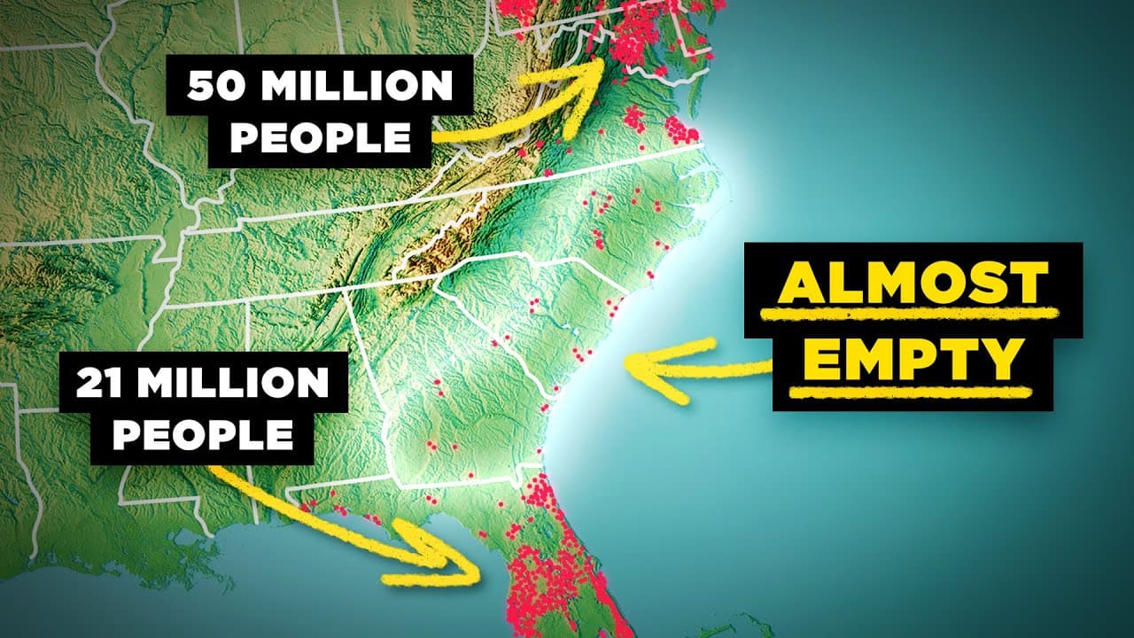
The Georgia and Carolina coasts are sparsely populated because their wide coastal plain has sandy, acidic, nutrient-poor soils, extensive wetlands, and difficult conditions for construction and settlement. Meanwhile, cities hundreds of kilometers inland benefited from fall-line cargo transfers, trade, and water-powered manufacturing. Read on to see how geography shifted population and economic activity away from the coast.
Transcript
This is a population density map of the United States, showing where most Americans currently live today. And if you pay attention to the southeastern corner of the country, an interesting pattern appears that's unlike anywhere else in the country. Here, across the states of Georgia, South Carolina, and North Carolina, the coastal areas are very sp... Read More
Key Insights
- The southeastern coastal population gap is concentrated across Georgia, South Carolina, and North Carolina, where many major urban areas lie hundreds of kilometers inland. Savannah, Charleston, and Wilmington are the principal coastal settlements discussed, but none is the largest metropolitan area in its state.
- The Atlantic coastal plain is much wider in Georgia and the Carolinas than it is farther north. It separates the Piedmont and Appalachian regions from the ocean by hundreds of kilometers, while narrowing progressively from Virginia toward New York City and Long Island.
- The coastal landscape south of New York City is generally smooth, sandy, marshy, and protected by long, thin barrier islands. North of the city, bedrock frequently reaches the coastline, producing rocky, hilly, jagged terrain without the same barrier-island pattern.
- The fall line is the boundary where rivers leave the elevated, hard bedrock of the Piedmont and enter the lower, flatter sediments of the coastal plain. The resulting decline in elevation creates the rapids and waterfalls that gave this geographic boundary its name.
- The fall line historically marked the inland limit of navigation for ships arriving from the Atlantic. Cargo and passengers had to be transferred to smaller vessels or wagons there, while goods traveling downstream from the interior also had to stop before the rapids.
- Fall-line settlements became trading hubs because they handled cargo transfers between the Piedmont interior and coastal harbors. The resulting demand supported warehousing, storage, banking, and trade, giving inland settlements a durable economic reason to grow beyond many coastal communities.
- Water power helped fall-line cities become early manufacturing centers. Rapids and waterfalls supplied energy for mills, while nearby Piedmont areas provided raw materials and downstream rivers connected finished goods with coastal harbors and global export markets.
- The Atlantic coastal plain has sandy, acidic, nutrient-poor soils and a high concentration of swamps and wetlands. These conditions create poorer drainage for agriculture and make infrastructure and settlement development more challenging than in the greener and generally more fertile Piedmont region.
Install to Summarize YouTube Videos and Get Transcripts
Explore YouTube Video Summarizer or Get YouTube Transcript Extractor
Questions & Answers
Q: Why are the Georgia and Carolina coasts sparsely populated?
Georgia, South Carolina, and North Carolina have an unusually wide Atlantic coastal plain with sandy, acidic, nutrient-poor soils, wetlands, and poor drainage. These conditions made agriculture, infrastructure, and settlement more difficult, while inland fall-line communities developed advantages in transportation, trade, and manufacturing.
Q: Why are the largest population centers in these states far inland?
Many major urban areas, including Atlanta, Augusta, Columbia, Greenville, Charlotte, Greensboro, Raleigh, and Durham, developed in the interior rather than on the coast. Inland settlements near the fall line became transfer points for cargo and passengers, supporting storage, banking, trade, mills, and manufacturing.
Q: What is the fall line in the eastern United States?
The fall line is the boundary between the higher Piedmont region, which sits on hard bedrock, and the lower, flatter Atlantic coastal plain. Rivers lose elevation while crossing this boundary, producing rapids and waterfalls.
Q: How did the fall line determine where cities developed?
The fall line marked the inland limit for ships arriving from the Atlantic because rapids and waterfalls blocked further navigation. Cargo and passengers had to transfer to smaller vessels or wagons, encouraging permanent settlements and commercial activity at those locations.
Q: Why did fall-line settlements become trading hubs?
Goods moving between the Piedmont interior and coastal harbors had to stop at the fall line. The resulting transfers created demand for cargo handling, warehousing, storage, banking, and trade, giving these inland settlements a durable economic advantage.
Q: How did waterfalls support manufacturing along the fall line?
Rapids and waterfalls supplied power for mills in fall-line settlements. These communities could obtain raw materials from the Piedmont and send finished goods downstream toward coastal harbors and global export markets.
Q: What physical conditions define the Atlantic coastal plain?
The Atlantic coastal plain is largely flat, sandy, and often swampy, with marshes, wetlands, and long, thin barrier islands along much of the coastline. Its acidic, nutrient-poor soils and drainage challenges made farming, construction, and settlement harder than in the greener, generally more fertile Piedmont.
Q: How unusual is the coastal population gap in Georgia and the Carolinas?
Savannah, Charleston, and Wilmington are the principal coastal settlements discussed, yet none is the largest metropolitan area in its state. Charleston has a metro population below 900,000, while Savannah and Wilmington each have fewer than 500,000 people, contrasting with the more heavily populated coastal areas to the north and in Florida.
Summary & Key Takeaways
-
Georgia, South Carolina, and North Carolina have an unusual population pattern. Their largest urban clusters generally sit far inland, while Savannah, Charleston, and Wilmington remain smaller than several interior metropolitan areas. This contrasts with the densely settled coastline from Virginia through Maine and the major coastal population centers of Florida.
-
The Atlantic coastal plain is especially wide across Georgia and the Carolinas. Its flat landscape contains sandy soils, marshes, swamps, wetlands, and barrier islands, making agriculture, drainage, infrastructure, and settlement more difficult. The neighboring Piedmont consists of rolling hills over hard bedrock and generally offers greener, more fertile agricultural land.
-
The fall line separates the elevated Piedmont from the lower coastal plain. Rivers crossing this boundary form rapids and waterfalls, which historically stopped ocean-going ships. Settlements grew where passengers and cargo had to transfer, creating inland centers for storage, banking, trade, mills, manufacturing, and connections between Piedmont resources and coastal ports.
Read in Other Languages (beta)
Share This Summary 📚
Summarize YouTube Videos and Get Video Transcripts with 1-Click
Try YouTube Summary with ChatGPT & Claude or YouTube Transcript Generator
Explore More Summaries from RealLifeLore 📚



Summarize YouTube Videos and Get Video Transcripts with 1-Click
Try YouTube Summary with ChatGPT & Claude or YouTube Transcript Generator