How to understand the Moroccan Berm Wall and Western Sahara
TL;DR
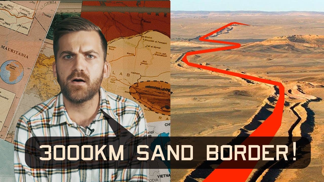
The Moroccan Berm Wall is a 3000 kilometer barrier of sand and dirt with mines that keeps most of Western Sahara under Moroccan control. Borders in Syria and Turkey involve historic relocations of assets like tombs and contested zones, illustrating how borders shape power, identity, and access to resources amid conflict.
Transcript
- I want to show you three borders that are very peculiar. Here they are. (dramatic music) One, two and three. And not just because they look weird on a map, but because of how they look in real life. (dramatic music) Us map nerds love looking at things that look weird on a map. Like this town that is cut up by a bunch of Dutch and Belgian enclaves... Read More
Key Insights
- The Moroccan Berm Wall stretches roughly 3000 kilometers and is designed to separate the Western Sahara region from Morocco proper.
- The wall is reinforced by troops, radar, underground bunkers, and a large number of landmines, making it one of the most dangerous border zones on earth.
- Western Sahara’s status is contested, with some countries not recognizing Moroccan claims and the United States briefly recognizing them in a political deal with Israel.
- US recognition of Moroccan sovereignty over Western Sahara occurred in the context of broader regional diplomacy, illustrating how external power dynamics influence border legitimacy.
- The Syrian border dynamic includes a tomb (grave) that Turkey claims as sovereign territory, illustrating how borders can be shaped by symbolic sites.
- Border adjustments in Syria and Turkey have involved moving a tomb within Syria closer to the Turkish border to protect it from conflict and ISIS destruction.
- The tomb’s relocation demonstrates how borders can be manipulated or redefined to protect cultural sovereignty amid war and territorial changes.
- Isis’s emergence in Syria intensified border security concerns and spurred subsequent political and military maneuvers around border areas.
- More videos from this channel:
- More from this channel: Johnny Harris
Install to Summarize YouTube Videos and Get Transcripts
Explore YouTube Video Summarizer or Get YouTube Transcript Extractor
Questions & Answers
Q: What is the Moroccan Berm Wall and why was it built?
The Moroccan Berm Wall is a nearly 3000 kilometer wall of sand and dirt that was constructed to keep Western Sahara’s local population from asserting independence and to allow Morocco to occupy the majority of the territory. It is defended by Moroccan troops with weaponry, radar, and underground bunkers, and it has become one of the most widely recognized landmine fields. Its purpose is to maintain Moroccan control over resource-rich areas while limiting separatist movements.
Q: How does the US position on Western Sahara affect the border situation?
The United States did not recognize Moroccan claims to Western Sahara for a long period, and it only shifted in a recent political context under the Trump administration as part of a broader deal with Morocco and Israel. This shift influenced the international legitimacy of the border lines and influenced which party is viewed as the controlling authority in the disputed region, impacting diplomacy and aid access.
Q: What is the significance of the tomb on the Euphrates in the Syria Turkey border story?
The tomb of a historic Turkish figure on the Euphrates was moved multiple times as borders and political control shifted. Initially located near a border, it was relocated north into Syria for protection during regional conflicts and then moved again closer to the Turkish border. This illustrates how symbolic sovereignty can be affected by dam projects, regional wars, and disputes over land.
Q: Why was the tomb moved a second time and what does that say about borders in conflict zones?
The tomb was moved a second time because Syria’s dam projects threatened to submerge the hill where the tomb stood, risking Turkish sovereignty symbolism. By relocating it near the border, Turkey preserved this symbol of sovereignty within a tense cross-border context. This shows how borders are not just lines but dynamic, culturally charged spaces that can be adjusted in response to military and infrastructural pressures.
Q: How does ISIS influence border dynamics in Syria according to the video?
ISIS’s rise and expansion into parts of Syria transformed border priorities by introducing threats to cultural heritage and complicating governance. The destruction of ancient sites by ISIS underscored the vulnerability of border regions to extremist violence, prompting Turkish, Syrian, and international actors to reexamine security, access, and the management of contested spaces along the border.
Q: What role do enclaves and border adjustments play in this border narrative?
Enclaves and small border adjustments reveal how states negotiate sovereignty over mixed territories and minority populations. They demonstrate that borders can be drawn and redrawn to reflect political leverage, resource control, and strategic interests, often leaving local communities navigating divided loyalties and uncertain governance.
Q: What is the broader lesson about borders from these three examples?
The three cases show that borders are living constructs shaped by political will, military power, cultural symbolism, and international diplomacy. They illustrate how states use walls, treaties, and relocations to control land and water, protect resources, and project sovereignty, often at the cost of local communities and heritage.
Q: How does map-based storytelling help explain these border complexities?
Map-based storytelling translates geographic complexity into accessible visuals, highlighting how lines on a map relate to real-world effects like security, population movement, and resource management. By tracing walls, enclaves, and moved monuments, the narrative reveals how abstract borders translate into concrete everyday experiences for people living nearby.
Summary & Key Takeaways
-
The Moroccan Berm Wall is a long sand and dirt barrier built to separate populations, containing weaponry and landmines that make it one of the most contentious borders in the world. The wall marks a conflict over land and resources in Western Sahara and underscores Morocco’s control efforts.
-
Border stories in Syria and Turkey show how borders can shift with political and military dynamics, including dam projects, territorial carve outs, and symbolic sovereignty symbols.
-
The video uses map-centric storytelling to reveal how borders are not just lines but living mechanisms that affect people, governance, and regional geopolitics, including changes in international recognition and local administration.
Read in Other Languages (beta)
Share This Summary 📚
Summarize YouTube Videos and Get Video Transcripts with 1-Click
Try YouTube Summary with ChatGPT & Claude or YouTube Transcript Generator
Explore More Summaries from Johnny Harris 📚



Summarize YouTube Videos and Get Video Transcripts with 1-Click
Try YouTube Summary with ChatGPT & Claude or YouTube Transcript Generator