How Does the International Date Line Work?
TL;DR
The International Date Line changes the calendar date because places on opposite sides can share nearly the same local time while sitting 12 hours ahead of and 12 hours behind Greenwich Mean Time. Its practical route zigzags around Russia, Alaska, Kiribati, Samoa, and other Pacific islands according to countries’ preferred dates and regional ties. Read on to understand the one-day jump, the line’s unusual shape, and why maps disagree.
Transcript
- A while back, I made a promise. (soft music) Someday, I'll make a video about this whole messy debacle. So today I intend to make good on that promise. Here we go. (upbeat music) This line is weird. It's not a border, but I guess it kind of is, it divides something. If it's Monday evening and you fly from Hawaii to New Zealand, you'll cross into ... Read More
Key Insights
- The International Date Line separates two calendar dates even where the local solar time is nearly identical. Around the Pacific, crossing the line can move a traveler from approximately 11:00 AM Tuesday to approximately 11:00 AM Monday without significantly changing the position of the sun.
- Global time is measured relative to Greenwich, where the conceptual model begins at zero. Places east of London become progressively later, while places west of London become progressively earlier, eventually creating a boundary between the end and beginning of a calendar day.
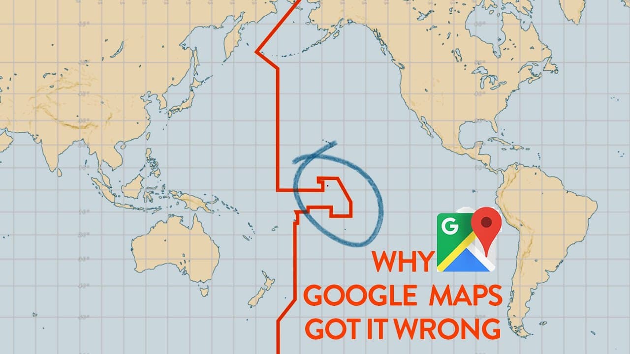
- The theoretical International Date Line is the 180th Meridian, located on the opposite side of the world from Greenwich. Its practical route is not straight because it bends around territories, countries, and island groups whose governments have chosen particular dates and regional alignments.
- The Date Line bends between Russia and Alaska to avoid dividing their territories between different dates. Two nearby islands on opposite sides of the line can therefore experience sunset at the same physical time while observing different calendar days, such as Tuesday on one island and Monday on the other.
- Kiribati is an island nation of about 112,000 people spread across an ocean area larger than the continental United States. The Date Line makes a large eastward notch so the entire country can observe the same date and remain aligned with Australia and Asia.
- Kiribati changed its date arrangement in 1995 because the previous line placed half the country on one date and half on another. This made domestic communication difficult, especially when one side reached Saturday while the other remained on Friday and followed a different work schedule.
- Samoa and American Samoa sit on opposite sides of the Date Line because they chose different regional alignments. Samoa is on the side associated with Australia and New Zealand, while American Samoa remains on the side associated with Hawaii and the United States.
- The International Date Line is not a sovereignty border controlled through ownership negotiations. Each country can decide unilaterally which date and time arrangement it wants, which explains why maps disagree and why the line has changed as national preferences have changed.
Install to Summarize YouTube Videos and Get Transcripts
Explore YouTube Video Summarizer or Get YouTube Transcript Extractor
Questions & Answers
Q: How does the International Date Line work?
The International Date Line separates places with nearly the same local solar time but different calendar dates. One side can be around 11:00 AM Tuesday because it is 12 hours ahead of Greenwich Mean Time, while the other is around 11:00 AM Monday because it is 12 hours behind.
Q: Why does crossing the International Date Line change the day?
Time becomes progressively later east of Greenwich and earlier west of it, creating a boundary between consecutive calendar dates in the Pacific. Crossing that boundary moves the stated date forward or backward by one day even when the sunlight and local clock time change very little.
Q: Does the International Date Line follow the 180th Meridian?
The theoretical Date Line follows the 180th Meridian, directly opposite Greenwich, but the practical line repeatedly departs from it. It bends to avoid dividing Russia, accommodate Alaskan islands, keep Kiribati together, and place Pacific nations on their preferred dates.
Q: Why does the International Date Line zigzag?
The line zigzags because countries and territories do not always want the 180th Meridian to split their land or island groups. Its bends allow places such as Russia, Alaska, Kiribati, Samoa, and American Samoa to maintain preferred dates or align with important regional partners.
Q: Who controls the International Date Line?
No single authority controls it as a conventional sovereignty border. Each country can choose its own date and time arrangement, allowing Pacific nations to change sides without negotiating ownership of territory.
Q: Why do maps disagree about the International Date Line?
Maps disagree because the Date Line is flexible rather than a precisely negotiated international border. The mapped versions examined differed by roughly 195 miles, or around 300 kilometers, and even placed some inhabited islands on opposite sides.
Q: Why did Kiribati change its Date Line arrangement?
Kiribati changed its arrangement in 1995 because the previous line placed parts of the country on different calendar dates. That division complicated domestic communication and weekly schedules, so Kiribati moved its islands onto the same date.
Q: Why are Samoa and American Samoa on different dates?
They chose different regional alignments despite being near one another. Samoa follows the side associated with Australia and New Zealand, while American Samoa remains aligned with Hawaii and the United States, so they observe consecutive calendar dates.
Summary & Key Takeaways
-
The International Date Line separates places experiencing different calendar dates at approximately the same local time. Near the middle of the Pacific, one side can be around 11:00 AM Tuesday while the other is around 11:00 AM Monday because their time offsets sit on opposite sides of Greenwich Mean Time.
-
A simple theoretical date line would follow the 180th Meridian, directly opposite Greenwich. The actual line departs from it repeatedly to avoid dividing Russia, accommodate Alaskan islands, keep Kiribati together, separate Samoa from American Samoa, and align other Pacific island nations with important regional countries such as Australia and New Zealand.
-
The Date Line is flexible because it is not a conventional international border that assigns sovereignty or ownership. Pacific countries can unilaterally choose their preferred date. Kiribati changed its arrangement in 1995 after the earlier division placed parts of the same country on different dates, complicating communication and weekly schedules.
Read in Other Languages (beta)
Share This Summary 📚
Summarize YouTube Videos and Get Video Transcripts with 1-Click
Try YouTube Summary with ChatGPT & Claude or YouTube Transcript Generator
Explore More Summaries from Johnny Harris 📚






Summarize YouTube Videos and Get Video Transcripts with 1-Click
Try YouTube Summary with ChatGPT & Claude or YouTube Transcript Generator