What Caused the 2025 Quy Nhon Flooding?
TL;DR
Persistent rainfall exceeding 1,100 millimeters in some areas caused rivers to overflow and submerged parts of Quy Nhon under as much as two meters of water. Evacuations, infrastructure failures, agricultural destruction, and losses initially estimated above 300 billion Vietnamese dong showed the need for stronger warning systems, safer urban planning, ecosystem restoration, and community-centered recovery.
Transcript
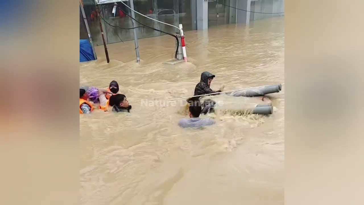
In mid- November 2025, the coastal city of Quean in Bindin province, central Vietnam, was struck by massive flooding, causing widespread damage, mass evacuations, and serious disruption to the daily lives of its residents. Heavy rains that fell for nearly a week triggered river overflows, chest deep water inundation, and unprecedented infrastructur... Read More
Key Insights
- The flooding was triggered by persistent heavy rain after a South China Sea low-pressure system carried humid air northwestward and encountered warm mainland air. This weather pattern drenched central coastal and mountainous areas, causing major rivers around Quy Nhon to overflow.
- Rainfall exceeded 1,100 millimeters in some areas within fewer than five days, far above the normal November level described in the source. The resulting river overflows inundated homes, roads, public facilities, agricultural land, and central districts under water reaching two meters.
- Emergency operations included evacuation posts established in schools and village halls, supported by military and police rescue teams. Rubber boats and amphibious vehicles were used to reach residents, including people trapped on second floors or rooftops while waiting for assistance.
- Infrastructure damage included highways severed by landslides and erosion, collapsed suburban bridges, overwhelmed drainage, submerged transmitter towers, and power outages lasting more than two days in some locations. Phu Cat Airport also temporarily closed because its runway flooded and access roads became impassable.
- Economic losses were initially estimated above 300 billion Vietnamese dong, with further increases expected during assessment and recovery. Rice fields, salt pans, shrimp ponds, and fish ponds were damaged, while Quy Nhon Port temporarily suspended operations because high tides and flooding affected logistics areas.
- Poor residents in low-lying areas and along riverbanks were among the most severely affected because many lost homes, possessions, livelihoods, and basic services. Relocation may create further conflict unless communities participate and receive fair compensation, employment access, and educational opportunities.
- Ecosystem degradation increased flood vulnerability through upstream deforestation, mangrove conversion, and hillside development without proper environmental assessment. Proposed long-term measures include mangrove restoration, watershed rehabilitation, watershed protection, and controlled hillside development to reduce risk while supporting coastal livelihoods.
- Long-term resilience requires stronger early warnings, coordinated agencies, climate-informed spatial planning, transparent aid, and continued mental health support. Vietnamese universities are also developing flood-modeling systems using satellite data and artificial intelligence to improve forecasting and disaster preparedness.
Install to Summarize YouTube Videos and Get Transcripts
Explore YouTube Video Summarizer or Get YouTube Transcript Extractor
Questions & Answers
Q: What caused the 2025 flooding in Quy Nhon?
The flooding followed the formation of a low-pressure system over the South China Sea that moved northwestward. It carried high humidity that encountered warm air from the Vietnamese mainland, producing persistent heavy rain across coastal and central mountainous areas. In fewer than five days, rainfall exceeded 1,100 millimeters in some locations, causing the Ha Thanh and Kon rivers to overflow.
Q: How severe was the flooding in Quy Nhon?
The flooding submerged parts of downtown Quy Nhon, including the Hai Cang and Tran Phu districts, under as much as two meters of water. Homes, shops, schools, roads, public facilities, and agricultural areas were inundated. Many residents evacuated to higher ground, while others became trapped on second floors or rooftops and waited for rescue teams to reach them.
Q: How were residents rescued during the Quy Nhon floods?
The Binh Dinh provincial government activated its emergency response system and established evacuation posts in schools and village halls. Military and police rescue teams used rubber boats and amphibious vehicles to evacuate residents from flooded neighborhoods. These operations assisted people who could reach higher ground as well as those stranded on rooftops or upper floors of inundated homes.
Q: What infrastructure was damaged by the Quy Nhon flooding?
National highways connecting Quy Nhon with other central Vietnamese cities were cut by landslides and erosion, while strong currents collapsed small suburban bridges. The drainage system could not handle the water volume. Some locations lost electricity for more than two days, communications were interrupted, and Phu Cat Airport temporarily closed because of runway flooding and impassable access roads.
Q: What were the economic effects of the Binh Dinh floods?
Initial losses were estimated above 300 billion Vietnamese dong, with the total expected to rise as assessments continued. Thousands of hectares of rice fields and salt pans were destroyed, including rice nearing harvest. Mud and sewage contaminated shrimp and fish ponds, and Quy Nhon Port temporarily suspended operations because high tides and flooding affected its logistics areas.
Q: How did the floods affect health, education, and daily life?
Children could not attend classes because schools were flooded or converted into evacuation centers. Health services faced residents with minor injuries, skin infections, and respiratory problems linked to dirty water and humid conditions. Families rapidly lost homes, possessions, and livelihoods, creating psychological trauma and uncertainty that the source says will require continuing mental health and psychosocial support.
Q: Why were low-income and riverside residents more vulnerable?
Poor residents living along riverbanks or in low-lying locations suffered heavily because their homes, possessions, livelihoods, and access to essential services were exposed to floodwater. The proposed relocation program could improve long-term safety, but the source warns that it may fuel social conflict without community participation, fair compensation, and reliable access to employment and education at new locations.
Q: How can Quy Nhon reduce the risk from future floods?
Proposed measures include stronger community-based early warnings, flood-control embankments and canals, improved interagency coordination, and spatial plans that restrict development in flood-prone zones. The source also recommends incorporating climate data into planning, restoring mangroves, protecting and rehabilitating watersheds, controlling hillside development, and using flood models based on satellite data and artificial intelligence to improve preparedness.
Summary & Key Takeaways
-
A low-pressure system over the South China Sea moved northwest and brought humid air into contact with warm mainland air, producing persistent rain across coastal and mountainous areas. Rainfall exceeded 1,100 millimeters in some places within five days, overflowing the Ha Thanh and Kon rivers and inundating Quy Nhon.
-
Floodwater reached up to two meters in downtown areas, forcing evacuations and trapping some residents on upper floors and rooftops. Landslides, erosion, bridge collapses, power outages, communications failures, airport closure, and overwhelmed drainage disrupted transportation and essential services while military and police teams conducted rescues.
-
Recovery proposals combine infrastructure reconstruction, direct assistance, relocation, improved warnings, flood-control works, and revised spatial planning. The source also advocates mangrove restoration, watershed protection, controlled hillside development, community participation, fair compensation, transparent aid distribution, and continued psychological support to create a safer and more sustainable city.
Read in Other Languages (beta)
Share This Summary 📚
Summarize YouTube Videos and Get Video Transcripts with 1-Click
Try YouTube Summary with ChatGPT & Claude or YouTube Transcript Generator
Explore More Summaries from Nature Damage 📚




Summarize YouTube Videos and Get Video Transcripts with 1-Click
Try YouTube Summary with ChatGPT & Claude or YouTube Transcript Generator