How Much Snow Fell in Ontario's Record November Storm?

TL;DR
Gravenhurst received an estimated 140 cm, nearly 4.6 feet, of snow in 48 hours during Ontario’s record November storm. Lake-effect snow squalls and winds up to 80 km/h created whiteouts, contributed to more than 200 crashes in the Greater Toronto Area, closed nearly 100 km of Highway 11, and disrupted power and schools. Read on for snowfall totals, causes, closures, and safety impacts.
Transcript
A powerful multi-day winter storm system has unleashed a historic blast of winter weather across large swades of Ontario, shattering decades old snowfall records and forcing several municipalities to declare a state of emergency. The severe weather event characterized by intense lake effect snow squalls and powerful winds gusting up to 80 kmh has c... Read More
Key Insights
- Gravenhurst in the Muskoka region was one of the hardest-hit communities, recording an estimated 140 cm (nearly 4.6 feet) of snow over a 48-hour period, prompting an official state of emergency declared early Sunday.
- Lake-effect snow squalls drove the storm, forming when cold Arctic air moves over the relatively warmer waters of the Great Lakes, creating narrow, intense bands of snowfall with rates of 5 to 10 cm per hour in some squalls.
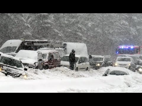
- Ontario Provincial Police attended more than 200 vehicle crashes across the Greater Toronto Area alone, as slick conditions, near-zero visibility, and sudden snow bursts caught drivers off guard in dangerous whiteout situations.
- A nearly 100 km stretch of Highway 11 between Orillia and Highway 60 in Huntsville was closed after becoming impassable due to stranded vehicles and massive snow drifts, requiring extensive plowing and recovery operations.
- Multiple communities logged massive accumulations, including Echo Bay at 136 cm, Bracebridge at 125 cm, and Sault Ste. Marie at 105 cm, with winds gusting up to 80 km/h across the province.
- A separate severe thunderstorm produced marble-like hail on Highway 11 near Allensville Road, causing an eight-vehicle pileup that killed one person and left three with life-altering or critical injuries.
- Environment Canada described the event as very rare for this much snow to fall this early, noting late-November totals were highly unusual and calling the short-duration snowfall amounts unbelievable.
- The Federal Weather Agency used its new color-coded alert system, upgrading warnings to an orange level in many areas to signal potentially life-threatening travel conditions, power cuts, and structural damage risk.
Install to Summarize YouTube Videos and Get Transcripts
Explore YouTube Video Summarizer or Get YouTube Transcript Extractor
Questions & Answers
Q: How much snow fell in Ontario’s record November storm?
Gravenhurst recorded an estimated 140 cm, nearly 4.6 feet, of snow over 48 hours. Echo Bay received 136 cm, Bracebridge 125 cm, and Sault Ste. Marie 105 cm.
Q: How much snow did Gravenhurst receive?
Gravenhurst, one of the hardest-hit communities in the Muskoka region, received an estimated 140 cm of snow in 48 hours. The town declared a state of emergency early Sunday.
Q: What caused the extreme snowfall in Ontario?
Potent lake-effect snow squalls formed as cold Arctic air moved over the relatively warmer Great Lakes. The resulting instability produced narrow, intense snow bands with snowfall rates of 5 to 10 cm per hour in some squalls.
Q: Why were travel conditions so dangerous?
Heavy snowfall and winds gusting up to 80 km/h frequently reduced visibility to near zero and created whiteout conditions. Slick roads and sudden bursts of snow caught drivers off guard, and authorities warned against non-essential travel.
Q: Why was Highway 11 closed during the storm?
Nearly 100 km of Highway 11 between Orillia and Highway 60 in Huntsville became impassable because of stranded vehicles and massive snow drifts. Extensive plowing and vehicle-recovery work was required before the highway could reopen safely.
Q: How many vehicle crashes occurred during the Ontario storm?
Ontario Provincial Police attended more than 200 crashes across the Greater Toronto Area alone. The transcript attributes the hazardous driving conditions to slick roads, sudden snow bursts, strong winds, and near-zero visibility.
Q: How did the storm affect power and schools?
Thousands of Hydro One customers lost power as snow-laden or wind-battered trees and branches fell onto power lines. Several school boards also cancelled buses and closed schools on Friday.
Q: What did Ontario’s orange weather warning mean?
The federal weather agency upgraded warnings to orange in many areas under its new color-coded alert system. The orange level indicated potentially life-threatening travel conditions and risks of power cuts and structural damage from high winds.
Summary & Key Takeaways
-
A multi-day winter storm shattered decades-old snowfall records across Ontario's snow belt off Georgian Bay and Lake Huron. Gravenhurst recorded an estimated 140 cm in 48 hours, with Echo Bay at 136 cm, Bracebridge at 125 cm, and Sault Ste. Marie at 105 cm, forcing several municipalities to declare states of emergency.
-
Intense lake-effect snow squalls and 80 km/h winds created near-zero visibility, whiteout conditions, and slick roads. Ontario Provincial Police handled over 200 crashes in the Greater Toronto Area, and a nearly 100 km stretch of Highway 11 between Orillia and Huntsville closed due to stranded vehicles and snow drifts.
-
Thousands of Hydro One customers lost power as snow-laden trees and branches fell on lines. School boards cancelled buses and closed schools, and a separate severe thunderstorm dumped marble-like hail on Highway 11, triggering an eight-vehicle pileup that killed one person and critically injured three others.
Read in Other Languages (beta)
Share This Summary 📚
Summarize YouTube Videos and Get Video Transcripts with 1-Click
Try YouTube Summary with ChatGPT & Claude or YouTube Transcript Generator
Explore More Summaries from Nature Damage 📚





Summarize YouTube Videos and Get Video Transcripts with 1-Click
Try YouTube Summary with ChatGPT & Claude or YouTube Transcript Generator