How to Build a Real-Time Geospatial Dashboard
TL;DR
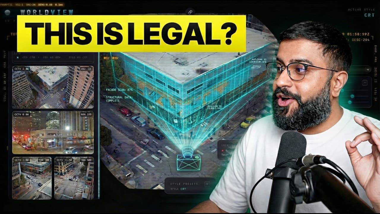
Bilawal Sidhu demonstrates the creation of WorldView, a geospatial dashboard combining live satellite tracking, real-time CCTV, and flight data using AI agents. Built in three days, it showcases the potential of AI and open-source data for creating advanced visualization tools. This project highlights the feasibility of integrating multiple data sources into a cohesive, interactive 3D model.
Transcript
[music] >> So I posted my latest coding project last night and woke up to a trending on X. It's like being shared by all these people. Oh yeah, vibe coded Palantir. Like we're replacing everything. Palantir is going down. I'm like this is World View and it's what happens when you take real-time satellite tracking, live CCTV cameras, military and co... Read More
Key Insights
- WorldView is a geospatial dashboard combining real-time data sources like satellite tracking, CCTV, and flight data into a 3D model.
- The project was built in three days using AI agents and open-source data, highlighting the power of AI in rapid development.
- Users can switch between modes like CRT, night vision, and FLIR, offering diverse visualization options directly in the browser.
- Live satellite tracking includes every satellite in orbit, allowing users to view orbits and track specific satellites in real-time.
- Real-time flight data integration allows tracking of over 6,700 planes, providing a comprehensive view of global air traffic.
- Military flights are tracked using ADS-B Exchange, showcasing the potential of open-source intelligence for monitoring purposes.
- Street traffic is simulated using OpenStreetMap data, emulating city traffic patterns in real-time.
- The project uses AI coding tools like Gemini 3.1 and Claude 4.6, demonstrating the potential of AI-assisted development in complex projects.
Install to Summarize YouTube Videos and Get Transcripts
Explore YouTube Video Summarizer or Get YouTube Transcript Extractor
Questions & Answers
Q: How does WorldView integrate real-time satellite tracking?
WorldView integrates real-time satellite tracking by utilizing data from various sources to display every satellite in orbit. Users can view and track specific satellites, seeing their orbits and details like geostationary or geosynchronous status. This integration showcases the potential of combining open-source data with advanced visualization techniques for real-time monitoring.
Q: What visualization modes are available in WorldView?
WorldView offers several visualization modes, including CRT, night vision, and FLIR, allowing users to switch between different visual effects directly in the browser. These modes enhance the user experience by providing diverse perspectives on the integrated data, making the dashboard feel like a spy thriller and offering a unique visualization of real-time global activities.
Q: How is real-time flight data incorporated into WorldView?
Real-time flight data is incorporated into WorldView using the OpenSky Network, which provides live tracking of over 6,700 planes. The dashboard displays global air traffic in real-time, allowing users to track specific flights and visualize their paths against a 3D model of the Earth. This integration highlights the potential of using open-source data for comprehensive, real-time monitoring.
Q: Can WorldView track military flights?
Yes, WorldView can track military flights using data from ADS-B Exchange, which relies on crowdsourced information to monitor military aircraft. This feature allows users to view and track military planes that are typically not included in standard flight tracking services, showcasing the power of open-source intelligence in providing a comprehensive view of global air traffic.
Q: What role do AI agents play in developing WorldView?
AI agents play a crucial role in developing WorldView by assisting in rapid coding and integration of multiple data sources. Tools like Gemini 3.1 and Claude 4.6 were used to automate tasks such as shader development, data integration, and visualization presets. This approach demonstrates the efficiency and potential of AI-assisted workflows in creating complex, real-time visualization tools.
Q: How does WorldView simulate street traffic?
WorldView simulates street traffic by using OpenStreetMap data to create a particle system that emulates city traffic patterns. This simulation allows users to visualize real-time traffic conditions in various cities, enhancing the dashboard's capability to provide a comprehensive operational picture of global activities. The simulation underscores the potential of integrating diverse data sources for advanced visualization.
Q: What data sources are used in WorldView?
WorldView uses a variety of data sources, including live satellite tracking, real-time CCTV feeds, flight data from the OpenSky Network, and military flight tracking via ADS-B Exchange. Additionally, it incorporates seismic activity data and street traffic simulations. These diverse sources are integrated into a 3D model, providing a comprehensive, real-time view of global activities.
Q: How does WorldView handle real-time CCTV data?
WorldView handles real-time CCTV data by integrating live feeds from publicly available cameras, such as those in Austin, Texas. These feeds are projected onto 3D geometry within the dashboard, allowing users to view real-time traffic and activities. Although the data updates at one frame per minute, it provides a realistic view of city conditions, enhancing the dashboard's operational picture.
Summary & Key Takeaways
-
WorldView integrates live satellite tracking, real-time CCTV, and flight data into a cohesive 3D geospatial dashboard, built in three days using AI agents. Users can visualize data in modes like CRT and night vision, offering a spy thriller-like experience. The project underscores the potential of AI and open-source data in creating advanced visualization tools.
-
Bilawal Sidhu's WorldView project demonstrates the fusion of real-time data sources, including satellite and flight tracking, with Google's 3D tiles. Built rapidly using AI agents, it allows users to interact with a comprehensive, real-time operational picture of global activities, showcasing the power of AI in creative tech development.
-
The project highlights the feasibility of using AI and open-source data to create sophisticated visualization tools. By integrating multiple data sources into a 3D model, WorldView offers a unique perspective on global activities, encouraging others with domain expertise to explore similar projects using AI-assisted workflows.
Read in Other Languages (beta)
Share This Summary 📚
Summarize YouTube Videos and Get Video Transcripts with 1-Click
Try YouTube Summary with ChatGPT & Claude or YouTube Transcript Generator
Explore More Summaries from Bilawal Sidhu 📚
Summarize YouTube Videos and Get Video Transcripts with 1-Click
Try YouTube Summary with ChatGPT & Claude or YouTube Transcript Generator