Can you find me? (Streetview on the Great Barrier Reef) - Smarter Every Day 114 | Summary and Q&A
TL;DR
Scientists use specialized equipment and software to survey and monitor the health of the Great Barrier Reef using data collected by Catlin Sea Survey and Google Street View.
Key Insights
- 👻 Google Street View allows for data collection and exploration without physical travel.
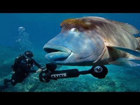
- 😒 Catlin Sea Survey uses specialized equipment like SV2 to survey coral reefs.
- 🫵 The quadrat view enables scientists to quantify the health of an ecosystem without extensive counting.
- 🪸 Coralnet software automates the identification and classification of coral species in the collected images.
- ❓ The data collected from the surveys is uploaded to globalreefrecord.org for scientific analysis.
- 🧑⚕️ The health of the Great Barrier Reef can be monitored and evaluated using the collected data.
- 💅 A connection to and appreciation for the beauty of coral reefs is important for conservation efforts.
Transcript
Hey it's me Destin, welcome back to Smarter Every Day. So one of the coolest things to me about Google streetview is the ability to explore a far off city and gather data without ever leaving the comfort of my own home. For example look at this one particular street in Amsterdam. There are two ducks sitting in the canal and there are three bicycles... Read More
Questions & Answers
Q: How does Catlin Sea Survey gather data about the decline of coral reefs?
Catlin Sea Survey uses specialized equipment called SV2 to capture panoramic images of the Great Barrier Reef, along with an autonomous software called coralnet, to analyze and quantify the health of the ecosystem.
Q: Why do scientists use a quadrat view to monitor the health of the reef?
The quadrat view is a standard reference frame that allows scientists to quantify species in a specific area, giving them an idea of the overall health of the ecosystem without the need to count individual organisms.
Q: How does coralnet software work?
Coralnet software uses automated recognition technology, similar to facial recognition, to identify and classify corals in the images. The software can determine the coverage of living coral, algae, and sand or dead coral, indicating the health of the reef.
Q: Why is it important for people to see and experience the beauty of coral reefs?
It is believed that unless people can see and appreciate the beauty of coral reefs, they won't feel a connection or care about their conservation. This highlights the importance of immersive experiences like virtual tours and exploration using technologies like Google Street View.
Summary & Key Takeaways
-
Google Street View allows users to explore distant locations and gather data without leaving home, including underwater areas like the Great Barrier Reef.
-
Catlin Sea Survey funded an effort to scientifically document the decline of coral reefs and used specialized equipment to survey the Great Barrier Reef.
-
The data collected from these surveys is uploaded to globalreefrecord.org and can be viewed using different modes, including an equirectangular view and a quadrat view which helps quantify the health of the ecosystem.
Share This Summary 📚
Explore More Summaries from SmarterEveryDay 📚